
Orthomosaics
Geometrically corrected, high-resolution aerial maps you can measure on directly.
NONG is the cloud platform that processes your aerial photos into accurate orthomosaics, point clouds, 3D models and survey-ready measurements — no specialist software required.
As featured on
Upload your images once and generate the full set of professional mapping deliverables.
Geometrically corrected, high-resolution aerial maps you can measure on directly.
Textured 3D meshes of buildings, terrain and sites for inspection and design.
Dense, georeferenced point clouds (LAS/LAZ) ready for CAD and GIS workflows.
Digital surface and terrain models for slope, drainage and elevation analysis.
Survey-ready contour lines at the interval you need, exportable to DXF.
Stockpile volumes, cut-and-fill and area measurements with a few clicks.
Fly any compatible drone, then drag your images into NONG — JPEG or RAW.
Our cloud photogrammetry engine aligns images and builds your outputs automatically.
Measure, annotate and export — or share a live link with your client or team.
Ground control points and RTK/PPK support deliver centimetre-level precision.
No expensive workstation. Process large datasets on our infrastructure, anywhere.
Automated pipelines return most projects within hours, not days.
GeoTIFF, LAS/LAZ, DXF, OBJ and more — drop straight into CAD and GIS tools.
Invite teammates and clients to view, comment and download in one workspace.
Encrypted storage and transfer keep your project data private and protected.
From topographic surveys to crop health, NONG adapts to how your industry works.
Topographic surveys, boundary maps and as-builts with traceable accuracy.
Track progress, compute earthworks and keep stakeholders aligned on site.
Vegetation indices and field maps to scout crop health and plan inputs.
Measure stockpiles and pit volumes safely without putting crews at risk.
Inspect lines, solar farms and assets with georeferenced 3D detail.
Monitor erosion, water and vegetation change across seasons.
NONG founder Gabriel do Nascimento was featured on Record's “Fala Brasil” (AGRO+), spotlighting how drone technology is transforming Brazilian agriculture.
Watch the feature“Technology in agriculture is expected to generate 178,000 jobs.”
— Programa Fala Brasil · Record · AGRO+
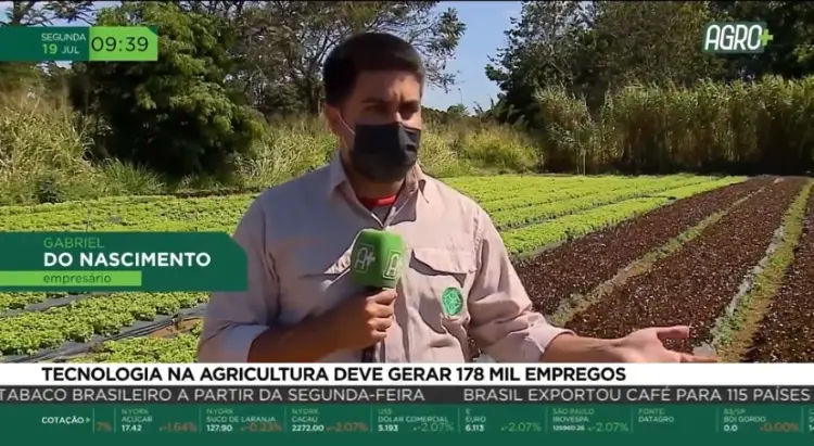
Gabriel do Nascimento · Founder, NONG
Every plan is quote-based, scaled to your volume, accuracy and turnaround needs.
For survey, construction and agriculture teams.
For organisations with high volume and SLAs.
Any drone that captures geotagged images works — from popular consumer models to professional RTK platforms. If your camera saves JPEG or RAW, NONG can process it.
With good overlap and ground control points (or RTK/PPK), NONG delivers centimetre-level relative accuracy suitable for survey work.
Orthomosaics as GeoTIFF, point clouds as LAS/LAZ, meshes as OBJ, vectors and contours as DXF, plus reports as PDF — ready for CAD and GIS.
Most projects finish within a few hours. Turnaround depends on image count and the outputs you request; Pro and Enterprise plans get priority queues.
Your imagery and outputs are encrypted in transit and at rest, and are only accessible to you and the people you invite to your workspace.
No. NONG automates the heavy lifting, and our specialists can help you set up your first flights and deliverables.
Tell us about your project and we’ll get back within one business day.
Prefer email? contato@nong.com.br